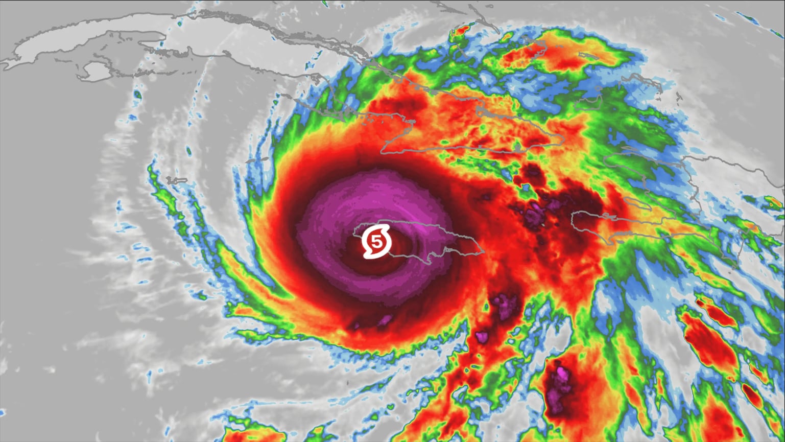
Hurricane Melissa has carved its name into meteorological history, leaving devastation and awe in equal measure. Now officially classified as a Category 5 storm, Melissa has become the most powerful hurricane ever to strike Jamaica directly—and one of the strongest ever recorded anywhere in the Atlantic basin. Its strength, scope, and record-breaking features have stunned meteorologists, emergency planners, and storm historians alike.
When Melissa made landfall, sustained winds reached a staggering 185 miles per hour, matching the all-time Atlantic record for the strongest hurricane to ever hit land. Only a handful of storms in history have come close to that level of fury. But Melissa’s intensity didn’t stop there. With a central pressure measured at 892 millibars, the storm tied the infamous 1935 Labor Day Hurricane—the deadliest and most powerful hurricane in U.S. history—as the most intense landfalling tropical cyclone ever documented in the Atlantic.
As the storm approached the Jamaican coast, Hurricane Hunter aircraft flew directly into its eye, gathering critical data. What they found defied expectations. Instruments recorded an instantaneous wind gust of 252 miles per hour just above the ocean’s surface. That number is extraordinary—it falls just one mile per hour short of the global record, set during Cyclone Olivia’s 1996 landfall in Western Australia, when gusts reached 253 mph. For meteorologists, such data points are almost unthinkable. They illustrate not just the raw power of this system but also the evolving threat of ultra-intense tropical cyclones in a warming climate.
In Jamaica, the storm’s impact has been catastrophic. Even though the nation has experienced its share of major hurricanes, nothing in living memory compares to the onslaught Melissa delivered. The storm’s eye crossed the island’s northern coastline near Montego Bay, shredding infrastructure, flattening homes, and uprooting entire neighborhoods. Early assessments indicate widespread destruction across multiple parishes. Entire power grids failed within hours, and floodwaters swept through inland towns where residents had sought refuge from the winds. Emergency responders described scenes of “total devastation,” with roads blocked by fallen trees and debris. In coastal areas, the storm surge exceeded 20 feet in some places, submerging ports and leaving fishing villages completely underwater.
Meteorologists across the Atlantic have noted how unusual Melissa’s structure and behavior were from the start. The storm intensified with astonishing speed—jumping from a Category 2 to a Category 5 in less than 24 hours. Such “rapid intensification” events are becoming increasingly common, but Melissa’s acceleration still stunned forecasters. The combination of exceptionally warm sea surface temperatures, low wind shear, and abundant atmospheric moisture created what one researcher called “the perfect recipe for explosive growth.”
Once the storm reached its peak strength, satellite imagery showed a near-perfect circular eye surrounded by symmetrical bands of clouds—an unmistakable hallmark of the most powerful hurricanes. The storm’s sheer size meant that hurricane-force winds extended more than 70 miles from the center, with tropical-storm conditions stretching several hundred miles farther. By the time Melissa reached Jamaica, it had evolved into a monster system that combined compact, violent winds with a massive outer circulation capable of wreaking havoc far from the eye itself.
For meteorologists and historians, Melissa’s intensity evokes comparisons to the few megastorms that have defined the modern hurricane era—Hurricane Dorian in 2019, Hurricane Gilbert in 1988, and the 1935 Labor Day Hurricane. Yet even among these, Melissa stands out for its combination of wind speed, pressure, and sustained duration over land. It didn’t just brush the island—it slammed into it head-on with unprecedented force.
Hurricane Hunter crews described the experience of flying into Melissa as “like nothing we’ve ever seen.” Pilots reported extreme turbulence, structural vibration, and wind shear so powerful that onboard instruments maxed out during several passes through the eyewall. Their data confirmed what satellite images had already suggested: Melissa wasn’t just powerful—it was near the physical limits of what a tropical cyclone can reach on Earth.
Experts also note that Melissa’s development highlights broader trends in the Atlantic. Over the past decade, ocean temperatures in the region where Melissa formed have been consistently above historical averages. These warmer waters serve as the fuel hurricanes need to grow stronger and more rapidly. Scientists have warned for years that rising sea temperatures could lead to more frequent and more intense storms—a prediction that Melissa has embodied with terrifying clarity.
Across the Caribbean, countries scrambled to prepare as the storm approached. Despite early warnings and evacuation orders, the storm’s unexpected acceleration left many communities with little time to act. Shelters quickly filled to capacity. Airports shut down. In Kingston, winds shattered windows in high-rise buildings, while landslides blocked highways in rural mountain areas. Offshore, cargo ships sought refuge, though several were reported missing as the storm’s waves reached heights of over 50 feet.
Beyond Jamaica, the wider Atlantic basin is still reeling from Melissa’s sheer magnitude. Meteorologists are tracking the storm’s remnants as it moves northwest toward the Bahamas, with projections suggesting that even as it weakens, it could still produce hurricane-force winds and life-threatening rainfall. The storm’s vast circulation continues to disrupt marine traffic and weather systems across the region.
Comparisons to historical storms help put Melissa’s strength into perspective. The Labor Day Hurricane of 1935, which previously held the record for intensity, killed more than 400 people in the Florida Keys. Hurricane Gilbert in 1988, which also hit Jamaica, reached wind speeds of 185 mph but had a central pressure slightly higher than Melissa’s. Hurricane Dorian in 2019 devastated the Bahamas with sustained winds of 185 mph and gusts near 220 mph. Yet none of these managed to record an official gust as high as Melissa’s 252 mph reading. In raw meteorological terms, Melissa is in a category of its own.
In the aftermath, rescue and relief operations are underway across Jamaica, but progress is slow. Many communities remain inaccessible due to flooding and downed power lines. The Jamaican government has declared a state of national emergency, and international aid agencies are mobilizing to provide food, clean water, and temporary shelter. Early reports estimate that tens of thousands have been displaced, with infrastructure damage expected to run into the billions. The full human toll is still being assessed.
For those who study hurricanes, Melissa is not only a humanitarian crisis but also a scientific wake-up call. Its rapid intensification, near-record winds, and extreme pressure readings will be analyzed for years to come. Some experts believe it could prompt a re-evaluation of how storms are categorized and forecasted in a world of shifting climate dynamics.
Melissa’s name will almost certainly be retired from future hurricane lists—a somber honor reserved for storms so deadly or destructive that their names can never be used again. For Jamaica, and for the wider Atlantic community, it will remain a defining event, a reminder of nature’s raw and unpredictable power.
In the words of one meteorologist: “Melissa wasn’t just another hurricane—it was a benchmark. The kind of storm that forces us to rethink what’s possible.”